11 November 2016

Amateur Radio in the Great Southwest - QSO's, Cactus, and Shotguns

I miss the days when I had a nice beam and a home station that was always available to operate.  My current home QTH does not have that luxury, so I'm forced to seek opportunities to engage in my ham hobby in alternate ways, one of which has been the Summits On The Air (SOTA) program.  As my interest in SOTA grows, I am learning that there are a great many peaks in Arizona just waiting for an intrepid ham.

My work schedule occasionally requires me to visit clients, and on Friday November 11th I had arranged a meeting in Casa Grande.  It seemed like a lot of driving for only an hour's meeting, so I checked the SOTA Mapping site to see if any peaks were nearby that I could activate afterwards.  I was excited to discover that there was a 2-pointer peak very close to where I would be!  Further investigation took me to the Casa Grande Mountain Trails Project website, which seemed to indicate that there were plenty of trails meandering through a pleasant desert landscape.

So with great anticipation I decided to activate Casa Grande Mountain HP, SOTA W7A/ PN-125.  I packed my gear and threw it in the car along with some hiking clothes.


  I was done with the meeting before noon and headed over to the parking area off Arica Road.


It didn't look too bad!  I set off on the trail and even had a simple map that I printed from the website.  It all seemed quite simple - make my way on to the Ridge Trail, head a bit North, then take a short off-trail scramble to reach the summit.  My planned route appeared to be less than a mile to the top.  At the beginning, the trails were nice and easy.  I even found a sign after winding around a bit, which let me know I had made it onto the Ridge Trail.


It was a rather warm day, as I expected at mid-day in low desert elevation.  The desert has a stark beauty to it, and often shows signs of life under harsh conditions.  Cactus are thorny, rocks are jagged, critters are dry and scaly, and sometimes death lies exposed as if to remind one of the challenging environment.


Oddly, the Ridge Trail does not actually go along the ridge, but rather it goes below it.  I had gone a little too far South at the beginning, and after about 1.7 miles I decided it was time to forge up the mountainside to reach the summit.  I knew this was not going to be an easy scramble as soon as I began.


If you zoom way in, you can see a tiny flagpole near the top of this photo - that is the peak.  So I set my sights on that as a goal and headed on up.  The rocks were crazy hard and cactus were everywhere!  In fact, I managed to lodge a nasty piece of jumping cholla deep into my calf muscle.  This is one of the hazards of desert life, and those of us who live in Southern Arizona know all too well what it feels like.  You can't simply remove a cholla by scraping it away either :-(


The climb became quite steep nearer the top.


I did finally reach the top (and also found a small trail leading in from the sides that I didn't know about!)  There was a flag that someone had left up there, along with about 6 dirty old tins that people had left full of summit registers and miscellaneous trash.


The hike up had taken much longer than I had expected so my operating time was not nearly as long as I had hoped for.  I worked mostly cw.  I made a couple of contacts with Tom, NQ7R, who lives right near the base of the mountain - we even had my first 2m SOTA QSO using FM simplex from my HT.  There is a shooting range to the West and during the entire activation, loud gunshots were blasting and I was nervous about ricocheting bullets!


I made 29 QSO's on 40m and 20m before packing it up.  On the way out, I decided to attempt a different route back, which took me along the true ridge.  This turned out to be a mistake, as it took a very long time before I was able to descend.


The route rolled up and down along various sub-peaks.  At the top of one, I found some rocks arranged in a tri-pattern, all pointing inward towards this marker which apparently was placed there in 1966.


Finally, late in the afternoon, I reached a point where the only way to go was down - and it wasn't too easy.


I did make it out alive, with a swollen calf and legs that were far more exhausted than the original plan had called for.  Maybe that's why this particular summit had never been activated before?  Anyway, I was happy to add another summit activation to my log and a couple more points to my activator total.




04 November 2016

Working the World from Oracle Ridge Summit

There are quite a few summits to climb around my home QTH in Tucson.  I was ready for another hike and my buddy Quinton, NU7Y, was off work so we decided to do a SOTA activation on Oracle Ridge, W7A/PE-004.  Quinton had researched possible summits and another local ham, K6HPX had activated Oracle Ridge a week ago, so we had some good info about how to approach the summit.  We decided to drive up the Mt. Lemmon Highway and start hiking along the Arizona Trail from a parking lot near the fire station on the ridge below Ski Valley.  On the map, it appeared to be a moderately long but fairly easy hike.

The trail was beautiful, and the weather was cool when we began hiking a bit before 9 am.  The trail started just under 8,000 feet and was net downhill towards the summit (until the final climb), but it went up and down over several peaks along the way.


The terrain was rocky and bushy, with lots of interesting weather-worn trees.  For some reason we could not determine, there is a fence running much of the way along the ridge.


About an hour into the hike, we could see our destination far off in the distance.


We also saw some ominous clouds moving in!  One fast-moving one had a vertical wall that was rapidly sweeping across the sky and eventually obstructed our view.  We began to be concerned that we might be hiking into a rainstorm, but we kept moving ahead.


After about 3 1/4 miles of hiking, we were close to the summit.  Unfortunately, the trail does not lead to the summit.  We were already getting weary, but the only way to the top involved a "bushwhack" up some steep, crowded terrain.  The pace of our hike became very slow as we climbed up.


When I finally reached the top, I took a short break to have a sandwich and take in the view.  Actually, there wasn't much view, as I was pretty much in the clouds.


We had planned to operate two independent stations, but when Quinton set his up he discovered some antenna problems.  So we both worked with my KX2 and OCF dipole.  Conditions were good on the bands but we were tired from the long hike!


We worked CW for a while, on several bands.


One of my favorite QSO's of the day was when I worked ZL1BYZ, John from New Zealand, on 15 meters.  He actually sent me an email with an mp3 recording of my calling after our QSO, and I was amazed to hear how strong my signal was - 5 watts to NZ was plenty!


I also worked a few stations on phone before we wrapped things up.


Since the hike in took so long, we knew we could not stay long so I only ended up with 29 QSO's for the day, including one Summit-to-Summit contact.  We packed up quickly and began the trek out.  Going back was a little faster but we chose the right time to leave - the sun was nearly set when we finished up the hike.


I ran my Yaesu FT-2D in APRS mode on the hike and it recorded a somewhat accurate track - my experience with RF-based APRS tracking using only an HT hasn't been very good, it tends to not make it in to the digipeaters very often due to the high volume of APRS traffic.  Here's the track result:


I'm really happy we did this hike, but I'm not sure I will be too eager to do Oracle Ridge anytime again soon.  It was an awesome way to spend a day with my friend, and we made some nice QSO's and enjoyed perfect weather conditions.  But, it was a difficult hike (off-trail bushwhacking seems to be a trend in reaching SOTA peaks?).  We'll see what comes next!


03 November 2016

Current SOTA Kit

When it comes to portable operations, there are unique challenges with regards to assembling the best amateur radio station.  In addition to the usual cost considerations, planned uses, and operating style and ergonomic preferences, it's necessary to think about minimizing weight and size.  A portable setup that can be transported in a car may have some flexibility (see my previous post regarding my amateur radio Go-Box), but a ham station that will be carried in a backpack on a long, strenuous hike needs to be planned much more carefully.

As I've become more serious about the Summits On The Air (SOTA) program, I've learned more about ways to create a very small, very portable station.  My first experience with a tiny QRP rig was when I activated Heliograph Peak with my buddy Quinton, NU7Y, who introduced me to SOTA.


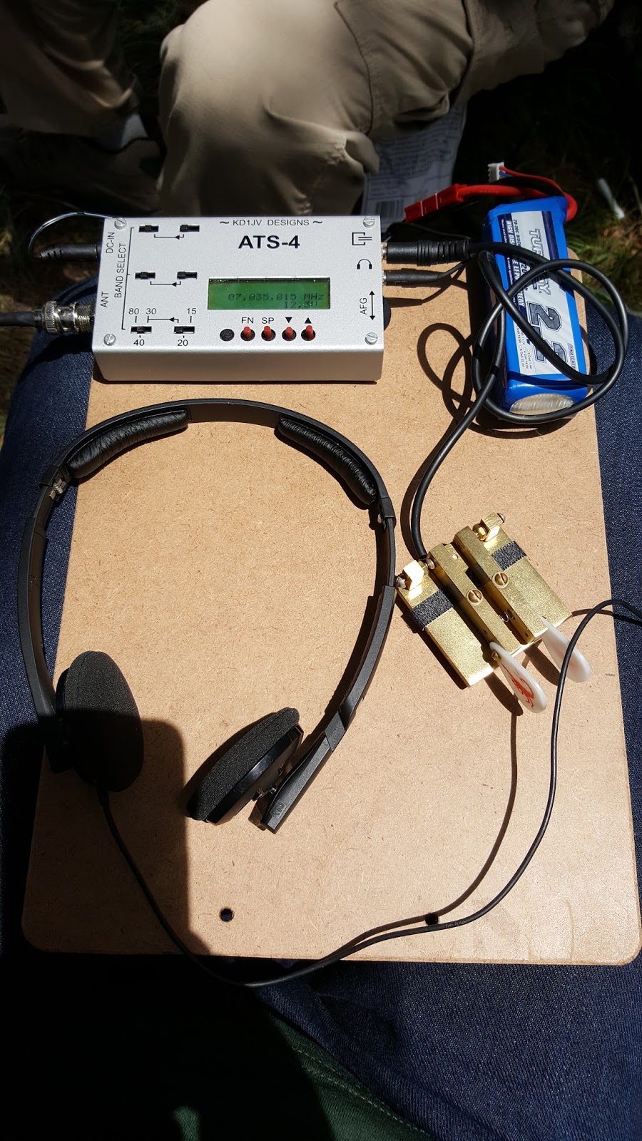
Much of my current setup is modeled after Quinton's rig.  I liked the clipboard idea, but for mine I decided on a bamboo cutting board that I purchased from Bed Bath & Beyond.  The wooden board allows me to drill holes to use for holding things securely during operation.  I also purchased a plastic waterproof case from Walmart to carry the gear (except antenna) in.  Here is the equipment that I take along:


I put some of the smaller items in plastic bags (bolts, clip for log and mic, earbuds, keyer cable, and spare battery) just to keep it tidy.  I also use microfiber sunglass carrying bags to wrap the Begali Traveler Light paddle and the microphone in, for a little protection while carrying.


I also wrap up the KX2 in a thin sheet of packing foam, to protect it from scratches.


Here's the plastic box - it's very similar to some expensive brands but it's a cheaper brand found in the camping section of Walmart.  I added a SOTA window sticker that I got from SOTABeams - it's perfect for this because it sticks from the inside so won't get rubbed off in the pack.


I also used packing tape to stick a copy of my FCC Amateur Radio License on the inside of the bottom.  This turned out to be a very helpful item when I went through airport security with the kit last week - they were quite interested in the contents of the box (and even swiped the KX2 with some sort of chemical sniffer), but showing the agent my license was useful.


The box came with an orange rubber divider inside.  I place my log notepad under it, and it also gives a slight padding for the other gear.  But it could also be pulled out and left behind.


I place the wrapped KX2, paddle, and microphone in the box on top of the notepad.


Then I fill in the remaining spaces with the plastic bags with the accessories and spare battery.


The final step is to fold up the SOTA flag, which I also purchased from SOTABeams,   This serves as a slight padding on the top of the case.  Then I snap it shut, and everything is in nice and neat, not to tight but also not jostling around, and ready to go out for another activation!


I have not weighed the loaded kit yet, but my guess is that it comes in around 3 - 4 pounds.  It's not feather-light, but for my hiking it has been a very nice way to transport my gear and feel safe about it in the pack.  I would love to see how others have designed their kits!


28 October 2016

Everything's Big in Texas - Except the Summit! Newton County HP, SOTA W5T/NT-039

My recent experience activating a peak in California made me want to do more activations while traveling.  Arizona has plenty of wonderful peaks and I'm looking forward to activating many more, but part of the fun of portable operations is, well, the “portable” aspect – which includes bringing gear along to many different places.  I had arranged to make a trip to Houston, Texas to visit my parents, so I decided to check the SOTA mapping project website and my SOTA Spotter App to see if there were any peaks nearby for a quick activation.


Much to my dismay, I discovered that the entire Houston area is basically a flatland.  I mean, really, really flat!  The closest peak I could find was about 145 miles away!

But hey, I'm trying to be a good SOTA op, so that means I need to embrace the challenge, right?  So I set to work on planning how to make this activation happen.  First, I located a ham in the Houston area who appeared to be an active SOTA guy, and emailed him to make sure I wasn't somehow missing something (was there a huge peak nearby that wasn't showing up in my search?)  His answer confirmed my fears; in fact he said that he drives over to NM and AZ to get peaks because it's so flat in Texas!  So, my only option appeared to be a one-pointer summit called “Newton County HP”, W5T/NT-039.  As an aside, I don't understand how this falls into the “North Texas” region, given its southerly locale, but that's not too important).  It took quite a bit of work to use MapQuest to find the best driving route, but eventually I got one that appeared to be near enough to get me in the area.

I was visiting primarily to care for my parents so being away for a long time would be a problem.  My solution was to leave very early, do the activation, and return later that morning.  With a 145 mile or so drive, this meant that I'd be on the air earlier than most US activations that are posted on SOTAWatch these days, but I didn't really have a choice.  On Friday, October 28th, I left their home for a long, dark drive.  It was foggy and dark but somehow I managed to get myself in the area just around sunrise.


I was driving East on Route 255, but had no exact directions from there.  So I pulled up the summit on the SOTAWatch App on my cell phone, which gave me a distance and direction.  As I approached it, I realized that the summit was not going to be on Route 255, but rather to the left.  There were occasional dirt roads leading off, but I had no idea where they led.  Eventually, as I drove, the app began to show me that the direction to the summit was now slightly behind me to the left; so I decided I'd better take a dirt road.


As it turned out, I was very lucky, because the dirt road I took (County Road #1105) did in fact lead me to the summit, which was on CR 1106!


 The summit was pretty obvious, because a few large commercial tower structures were present.
  

I pulled up alongside them on the dirt road and quickly set up my gear, as close as I could without trespassing beyond the Posted signs.  Actually I didn’t really want to be so close to the towers anyway.


I initially hoped to just sit on the ground, but almost immediately, a swarm of ants was marching all over my gear and myself!  So, I just decided to do the operation in a standing position.


It was a little challenging tapping the paddle but I managed to pull out 6 QSO’s on 40m, 6 on 30m, and 7 on 20m (including a phone Summit-to-Summit QSO with KK4OSG.  The bands seemed pretty good and I was having fun, but I had to shut down in less than an hour and head back to my take care of my folks.  Was it worth all that driving just for a very short 1-pointer QSO?  The answer is yes, it really was a fun time and I was happy to add another Association to my list.  Traveling with amateur radio has become much easier with the advent of the KX2 (although airport security did take it out of my bag and wipe it down with some sort of test strip on the way to TX).  I’m learning more about setting up a very quick multi-band system as well.  All in all, I’d say it was worth it!

25 October 2016

Begali Lineup

I've been a fan of Begali Keys since I purchased my first, the Sculpture, several years ago at the Dayton Hamvention.  I'm not a super-fast morse op, and the cost is rather high, but once you use a Begali it's hard to go back to using other keys.  The quality just gives a much smoother ride and the ability to fine-tune the adjustments lets me find the optimal feel.

Here is my current lineup of Begali Keys.  I use the Sculpture when I am at the home QTH.  The Traveler Lite goes out with me on portable operations.  And my latest addition, the Stradivarius, resides in my office for use on the remote setup.


21 October 2016

October OVARC Meeting - APRS

The October meeting of the Oro Valley Amateur Radio Club (OVARC) had an informative presentation on APRS by Bob, AF9W.  I began using APRS way back in the 1990's and had a lot of fun using various types of TNC's, GPS units, and displays.  For a while I had a nice weather station that beaconed APRS from my home QTH, and lately I've used it to beacon out my position along my SOTA hikes.

Technology has improved APRS a lot.  For example, many radios now have built-in TNC's and GPS units (like my Yaesu FT-2DR handheld).  Mapping back in the early days used DOS-driven software with rudimentary character-drawn maps, whereas now we have high-resolution mapping, satellite images, and super-fast colorful displays that draw very little power.  Websites like http://www.aprs.fi give near-real time aprs data via the internet.

As usual, the OVARC meeting had other interesting stuff including a demo of his Lindenblad Satellite Antenna project by Ron, W7HD, and a short Handyman's Corner talk by Tom, W8TK on how to build a $5 antenna tuner.


Green Mountain - Scrambling for SOTA W7A/PE-002

It's a nice time of year for hiking in Southern Arizona.  The mild Fall weather is a welcome change from the hot days of Summer.  After a couple of high-stress weeks at work, I was ready to hit the trails.  My oldest son, Ryan, was going to be available as well so we decided to do an easy hike in the Catalina mountain range on Friday, October 21st.

Ryan is also a licensed amateur radio operator, having earned his Technician class ticket at age 12.  His call sign is KR7YAN, and although he's not active on the bands, he enjoys hearing about my radio exploits.  So I thought this might be a good opportunity to do a SOTA activation and give him a chance to see the OM in action.

We chose Green Mountain, W7A/PE-002 as our target summit.  At about 2400m, this is a 10-pointer peak.  It’s close to the Mt. Lemmon Highway so it's possible to drive up to a starting point that is already at fairly high elevation.  Our goal was to hike a few miles, so we thought we would try the Green Mountain Trail.   The Green Mountain Trail winds around the mountain, but does not actually approach the summit.  It connects to the highway at two different points; we chose to start at the Upper trailhead.  Based on reviews of topo maps, as well as a few writeups from other hikers, we realized that to reach the summit, we would need to do some off-trail “scrambling”.


The start of the trail was easy hiking.  But it wasn't long before we had a bit of trail confusion.  There were unmarked trail junctions, and even the GPS (which has a very current mapset) seemed ambiguous.  Eventually we found a marker and confirmed that we were still on the correct trail, and by that time we were on the East side of the mountain and headed downhill.  The views were amazing, but looking up toward the summit, we realized that the terrain was nearly impossible for scrambling up on that side without some serious rock-climbing hardware.  So we turned back.  A couple of day-hikers wandered by and they were also terribly confused; their USGS topo map didn't match up to all the unmarked trails either.  On our way back we missed a turnoff but figured it out shortly thereafter.  Eventually we were back on the North side, only about a tenth of a mile from our original start point, and found a spot that we decided was worth a try for a summit scramble.


I was lugging my 40 pounds of stuff, because I thought it was going to be a short easy hike.  This included the daypack containing radio gear, water, food, emergency kit, etc, as well as the Buddipole bag with tripod, two antenna setups, analyzer etc.  Now that it's over, I'm happy that I brought all that, but at the time it was quite a challenge, because almost as soon as we started the off-trail climb, we were on very steep, loose rock terrain.


It was challenging but also the kind of challenge that makes you feel some pride.  There were parts of the climb that were overgrown as well.  But we pushed our way up and eventually reached a point below the summit that provided some spectacular views.


After a short break to enjoy the scenery, we trekked just a bit further to the summit.


Green Mountain has a large, grassy summit area and despite the high elevation there are plenty of trees, which we appreciated for shade.  We were fortunate to have perfect temperatures up there, not too cool or too hot.  Short walks to the edges provided views of Tucson, Mt. Bigelow, and Mt. Lemmon.  I set up the Buddipole in standard dipole configuration for 20 meters, and the Aerial 51 404-UL OCF dipole for use on other bands.


I began with 20 meters and made a bunch of CW QSO's.  The band was doing quite well and I almost felt spoiled with the nice big log to sit on.  I used my Elecraft  KX2 with internal batteries, so my power was only 5 watts, but the signals were getting out.  In addition to many stateside QSO's, I worked Canada, the Czech Republic, and France!  While I was making contacts, Ryan was relaxing.  I had hoped he might be willing to try a few 10m SSB, or 2m FM QSO's but he preferred to leave the operating to me.  I really did hope to operate on 10 meters, so after a while I moved over to the OCF which I had set up inverted V style, using my broken-but-still-useful SOTABeams push-up mast.


I did manage to make 4 10 meter QSO's, all local with the help of my friend Quinton, NU7Y and a few other guys who were following my progress on a local 2m repeater.  One funny QSO occurred when I tried to QSO with a guy who wanted a 10m SSB contact (it was all CW until then).  For some reason my KX2 was in lower sideband mode when I changed to phone, and I could not figure out how to change it to upper!  There's really no major reason for using USB instead of LSB, other than it's standard ham radio convention to use USB for 20m and higher.  So, we ended up making our QSO using LSB instead, which wasn't really an issue since the band was otherwise quiet anyway.  (I did check the manual later and learned that it's a simple menu option).  After a while on 10, I moved over to 40 meters and had some fun there.  It was nice to be able to switch bands on the wire antenna without any issues; I hit the ATU on the KX2 to bring the SWR to near-perfect, but it was pretty close anyway.  I could have changed bands on the Buddipole with only a few minutes work as well, but it was fun to be able to use both antennas.  Hopefully I will get a chance on a longer activation  sometime to do some comparisons between the two.  I suspect the Buddipole will be the better antenna overall for most purposes but the inverted V might have an advantage for closer stations using NVIS.

I went back to 20 meters eventually and worked some more stations there.  I added some great contacts to my log.  In addition to the DX mentioned earlier, one nice surprise was working my friend Karen, W4KRN, who I've known for many years as a result of our mutual interest in 10-10 International Net (wish our contact had been on 10 but it was still fun!)


This was a great activation on so many levels.  Lots of good QSO's with ham friends around the world; a challenging but short hike; perfect weather;  a 10-point summit;  a day off from work;  and time spent with Ryan.  Green Mountain was definitely a success!