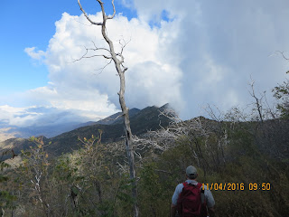
The trail was beautiful, and the weather was cool when we began hiking a bit before 9 am. The trail started just under 8,000 feet and was net downhill towards the summit (until the final climb), but it went up and down over several peaks along the way.
The terrain was rocky and bushy, with lots of interesting weather-worn trees. For some reason we could not determine, there is a fence running much of the way along the ridge.
About an hour into the hike, we could see our destination far off in the distance.
We also saw some ominous clouds moving in! One fast-moving one had a vertical wall that was rapidly sweeping across the sky and eventually obstructed our view. We began to be concerned that we might be hiking into a rainstorm, but we kept moving ahead.
After about 3 1/4 miles of hiking, we were close to the summit. Unfortunately, the trail does not lead to the summit. We were already getting weary, but the only way to the top involved a "bushwhack" up some steep, crowded terrain. The pace of our hike became very slow as we climbed up.
When I finally reached the top, I took a short break to have a sandwich and take in the view. Actually, there wasn't much view, as I was pretty much in the clouds.
We had planned to operate two independent stations, but when Quinton set his up he discovered some antenna problems. So we both worked with my KX2 and OCF dipole. Conditions were good on the bands but we were tired from the long hike!
We worked CW for a while, on several bands.
One of my favorite QSO's of the day was when I worked ZL1BYZ, John from New Zealand, on 15 meters. He actually sent me an email with an mp3 recording of my calling after our QSO, and I was amazed to hear how strong my signal was - 5 watts to NZ was plenty!
I also worked a few stations on phone before we wrapped things up.
Since the hike in took so long, we knew we could not stay long so I only ended up with 29 QSO's for the day, including one Summit-to-Summit contact. We packed up quickly and began the trek out. Going back was a little faster but we chose the right time to leave - the sun was nearly set when we finished up the hike.
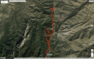
I ran my Yaesu FT-2D in APRS mode on the hike and it recorded a somewhat accurate track - my experience with RF-based APRS tracking using only an HT hasn't been very good, it tends to not make it in to the digipeaters very often due to the high volume of APRS traffic. Here's the track result:
I'm really happy we did this hike, but I'm not sure I will be too eager to do Oracle Ridge anytime again soon. It was an awesome way to spend a day with my friend, and we made some nice QSO's and enjoyed perfect weather conditions. But, it was a difficult hike (off-trail bushwhacking seems to be a trend in reaching SOTA peaks?). We'll see what comes next!


