I parked in the campground, hung my USFS pass in the window, and began my day of hiking about 7am. Early on, I could see the mountain looming in the distance, its rocky eastern sides looking rather intimidating.
Starting on the Hamburg Trail, I began the hike. The first 2.5 miles or so were actually downhill, dropping about 700' into Pat Scott Canyon and the Hamburg Mine. It was nice and cool, with a decent trail and plenty of trees. I even found some running water in a few places.
After the canyon, the steep climb began with multiple switchbacks.
Ramsey Peak was drawing closer, and continued to look rather interesting.
At about 4.7 miles in, I reached a junction with the Crest Trail. Turning North, I took a path that would take me across Pat Scott Peak on the way to Ramsey. There were some interesting sights including some discarded old mining equipment (which is not unusual in Arizona).
There were a few sections with steeper climbs and more evidence of human presence from days gone by as I continued onward.
Eventually the trail became less apparent - there clearly were not as many hikers who go this far up. But it did level out for a while and was pleasantly forested. I saw a deer run by and breathed in the fresh air as I prepared for the coming bushwhack.
At about the 5.5 mile mark, I reached a boundary sign to inform me that the trail was about to enter the Fort Huachuca Army Base. This is where the bushwhack to the summit begins, and there is a fence to define the boundary of the Coronado National Forest and the US Military property. Although I doubted that the army would have anyone stationed up there, I decided it was probably best not to be bushwhacking through the forest on the military side of the fence.
So, I began the final ascent up to the summit. At first, it looked relatively simple - a mild slope in the pines. However, that did not last long!
It was a tough, dense, and at times rather steep bushwhack to the summit. It took me almost another hour to hike that final mile. But I did reach the summit, and had a nice activation starting at about 11am. I was testing out a shorter (and lighter) push-up mast so my antenna wasn't quite as high as normal, but it all worked out well.
Since I had plenty of hiking ahead, I only ran 20 and 40 meters, for about 45 minutes, before packing up. The bushwhack down was just as rough, and I was glad to be back on trail after a mile down. I headed back along the Crest Trail, but at the junction I kept on going instead of turning back down towards the canyon. I was really enjoying this trail, being alone in the quiet forest, with plenty of scenery.
There are quite a few trails in the Huachucas, but fortunately I had carefully mapped out my route and saved it to my GPS in advance. The Crest Trail is actually part of the Arizona Trail, and although I didn't see any other hikers all day, I'm sure there had probably been some through-hikers in this area within the past few months.
Some areas of the hike took me through sections that had obviously experienced forest fires.
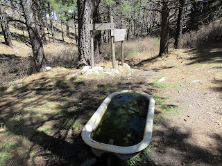
My second summit target, Miller Peak, was a fairly good hike away from Ramsey. Around 5 miles into the hike between the summits, I reached what I believe was "Bathtub Spring". This is also a trail junction and I stopped to take a drink before starting the next climbing section. I was very sweaty and grubby by this time, but I decided not to take a bath.
Continuing on, I soon saw Miller Peak tempting me in the distance, roughly 2.5 miles away, and about 700 feet higher.
I was beginning to get a bit tired at this point but the magic of the outdoors kept me feeling excited. As I got higher, there were even a few sections of trail that had a snowy surprise to cool me off.
I reached the final spur trail to Miller Peak and turned up for the final ascent. It was rocky and rough, but not too far to reach the summit.
I set up and began operating about 4pm, but kept it very short as it was chilly and I knew I only had a few hours of daylight to finish my hike.
The hike out was very nice, with long shadows and the stillness that slowly takes over wilderness as evening approaches. At one point I saw a deer who seemed surprised to see a human out here in his domain.
I walked so close to Carr Peak, in fact my final section of the hike took me right past the summit and around it, but there simply was not enough time to scurry up and activate. When I came around to the North side of the peak, I could see into Sierra Vista, and nearby was the famous tethered border surveillance blimp that has kept an eye on the area for many years.
The hike down after Carr Peak is rather steep and rocky, which was a bit tricky to navigate safely in low light.
I finished the hike right when twilight was pretty much done. The moon was full and was peeking through the treetops to add a mystical aura to the finish. The total mileage for the hike was 20.2 miles, with total elevation gain of around 5,400 feet. I was tired but very happy!
GPS Track Uploaded to SOTA Mapping Project Tracks Site: Yes
Approx Hiking Distance: 20.2 mi
Approx Elevation Gain: 5,400'
Summit Elevation: 8,737' (Ramsey Peak), 9,466' (Miller Peak)
Summit Grid Square: DM41tk (Ramsey Peak), DM41uj (Miller Peak)
Summit County: Cochise
ITU Zone: 6
CQ Zone: 3


